
Price: $63.95
(as of Sep 09, 2025 19:28:20 UTC – Details)

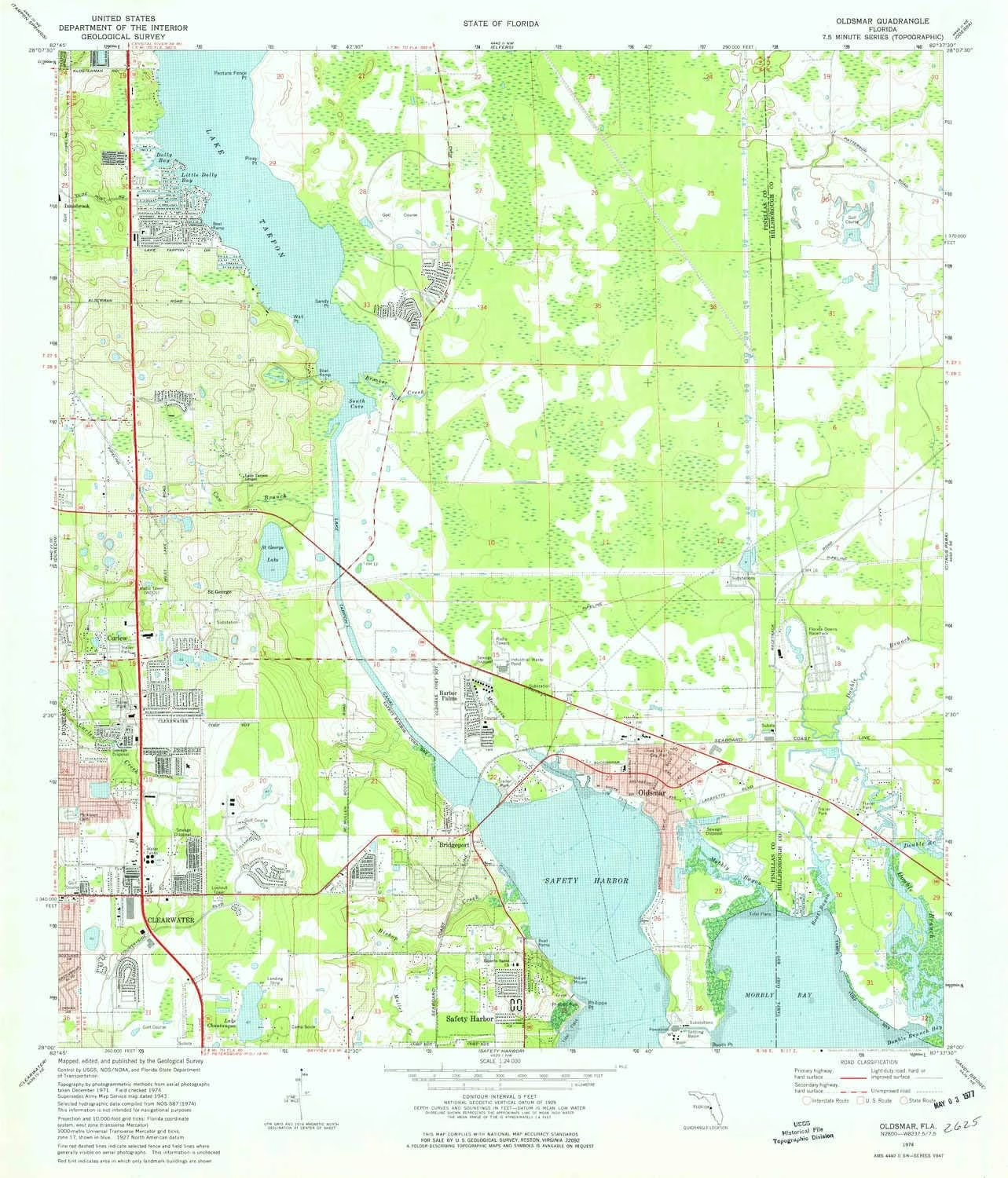
USGS topographic map of Oldsmar, Florida, dated 1974, updated 1976.
Includes geographic coordinates (latitude and longitude), lines of elevation, bodies of water, roads, and more. This topo quad is suitable for recreational, outdoor uses, office applications, or wall map framing.
Printed on-demand by YellowMaps on the print material of your choice.
Shipping rolled from Minneapolis, MN, United States.
Product Number: USGS-5626822
Map Size: 26.8 inches high x 23 inches wide
Map Scale: 1:24000
Map Type: POD USGS Topographic Map
Map Series: HTMC
Map Version: Historical
Cell ID: 33128
Scan ID: 347797
Imprint Year: 1976
Woodland Tint: Yes
Aerial Photo Year: 1971
Field Check Year: 1974
Datum: NAD27
Map Projection: Transverse Mercator
Map published by United States Geological Survey
Map Language: English
Scanner Resolution: 600 dpi
Map Cell Name: Oldsmar
Grid size: 7.5 X 7.5 Minute
Date on map: 1974
Geographical region: Florida, United States
Northern map edge Latitude: 28.125°
Southern map edge Latitude: 28°
Western map edge Longitude: -82.75°
Eastern map edge Longitude: -82.625°
Surrounding map sheets (copy & paste the Product No. in the search bar):
North: USGS-5623798,USGS-5620634,USGS-5623794,USGS-5623796,USGS-5620792
East: USGS-5622964,USGS-5622968,USGS-5622960,USGS-5622976,USGS-5622972
South: USGS-5620962,USGS-5627720,USGS-5627718,USGS-5627712,USGS-5627710
West: USGS-5623654,USGS-5623664,USGS-5623662,USGS-5623658,USGS-5623656
Printed on Polypropylene (plastic)
USGS topographic map of Oldsmar, FL, at 1:24000 scale. Heavier material. Waterproof. Tear-resistant. Foldable. Perfect for the outdoors.
Cities, towns, villages: Point at Mobbly Bay,Lake Shore Estates,Turnberry at the Eagles,Prestwick at The Eagles,Saint Andrews at the Eagles,Nine Eagles,East Lake,Curlew,Canterbury Village,Double Branch Estates,Canterbury North at the Eagles,Harbor Palms,Innfields,Royal Troon Village,Reolds Acre,River Chase,Bridgeport,Canterbury Heights at the Eagles,West Hampton,Country Chase,Saltmarsh,Hampton Lakes at Main Street,Westchester,Aston Villas,Reolds Farm,Westwood Lakes,Mecca,Oldsmar
Islands: Consult topo map preview for visible islands.
Parks and forests: Chautauqua Park North,Safety Harbor Site,Chautauqua Park South,Countryside Library Playground,Soule Road Park,D D Davis Park,Country Hollow Park,Cypress Point Park,Philippe Park,Mease Park,North Clearwater Nature Preserve,Mobbly Bayou Wilderness Preserve South Support Area,Cypress Bend Park,J Stephen Putnam Park,Canal Park,Bicentennial Park,Harbor Palms Nature Park and Estuary Preserve,Countryside Sports Complex,Veterans Memorial Park,John Chestnut Senior Park